First Alert Weather: Fabulous fall weekend on tap
[News10NBC]
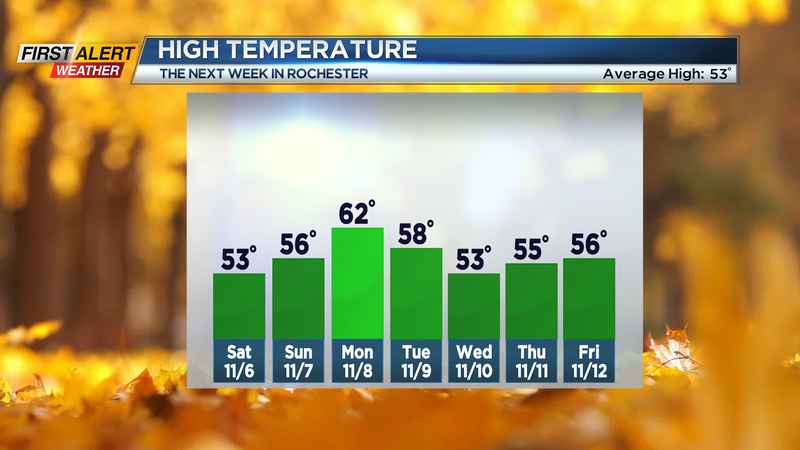
ROCHESTER, N.Y. (WHEC) — After a bunch of soggy weekends, we’re flipping the script this weekend! High-pressure building in will clear the clouds from the sky tonight, leading to another frosty morning Saturday, with temperatures below freezing for many away from the immediate Lake Ontario shoreline.
Despite that chilly start, we’ll recover quickly, making our way back into the lower 50s thanks to a mostly sunny sky. The picture-perfect fall weather continues into Sunday, with more blue sky overhead and temperatures a little milder — making it into the mid, maybe upper 50s. Much of the area will hit 60 on Monday with more dry weather and a partly cloudy sky.
This pattern will finally start to break down on Tuesday, with a weak disturbance starting to drop south, which will increase our clouds just a little bit, but any showers should hold off until Wednesday. Thursday looks dry, as we’re in between two systems.
The stronger storm system will arrive on Friday, with another round of showers, followed by a big cool down by next weekend. In fact, it’ll likely be cool enough on Saturday for some lake rain showers, and perhaps those rain showers mixing with some wet flakes later Saturday into Sunday. No big storm systems and no big snow is in the forecast for WNY in the foreseeable future.
———————————
Download the WHEC First Alert Weather app to stay up to date while on the go.
Watch the latest full forecast at whec.com/weather.