First Alert Weather: One more warm, stormy day Friday
[News10NBC]
ROCHESTER, N.Y. (WHEC) — Widespread severe storms developed this afternoon, but they developed east and south of our area. So the Yellow Alert up for Thursday has been dropped.
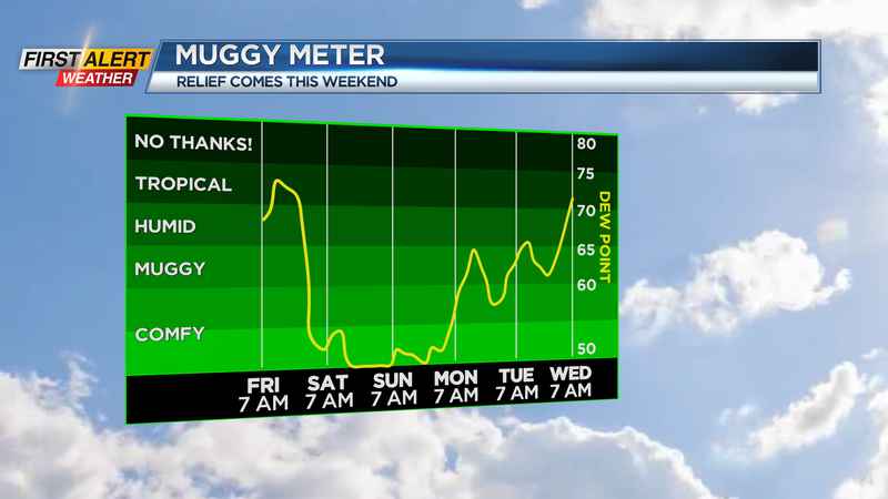
That being said, we aren’t quite done with the stormy weather for the week. A cold front will finally pass through on Friday, with one more round of showers and thunderstorms. A few of these storms could produce gusty winds and locally heavy rain, but the severe threat isn’t overly impressive at this time. Friday will start off warm, with temperatures in the lower 70s, and we’ll top out in the mid to upper 80s with one last day of muggy air.
The weekend is looking pretty nice, with the sky becoming mostly sunny on Saturday, along with lower humidity and cooler air for a change. Sunday will also be nice with a partly to mostly cloudy sky. Both days will top out in the mid to upper 70s for highs, and Sunday morning will start in the 50s for lows! So, we can go ahead and give our air conditioners a rest, and let some fresh air in.
The beginning of next week also looks pretty good, with seasonable temperatures in the upper 70s and lower 80s and dry weather Monday. Tuesday through Friday will feature increasing chances for rain and some thunder, but at this point, no big weather or storms.
We’ll keep an eye on the remnants of what was Tropical Storm Fred, and how much moisture gets drawn northward later next week. But any impacts should be minor overall.
__________
Download the WHEC First Alert Weather app to stay up to date while on the go.
Watch the latest full forecast at whec.com/weather.