First Alert Weather: Another shot of cold to end the work week
[News10NBC]
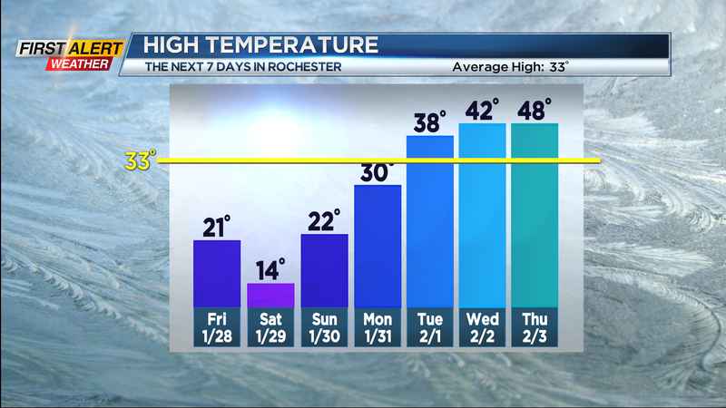
ROCHESTER, N.Y. (WHEC) — Temperatures came close to 30 across Western New York today, but we’re headed back down to end the workweek.
A cold front plunges south through the state tonight, with temperatures dropping to near 20 by morning, then through the teens on Friday. Wind chills will approach 0 by Friday afternoon. We’ll get a brief burst of snow with the front overnight, then some minor lake effect snow through Friday morning. Most will see less than 1" of snow tonight, and less than 1" of snow on Friday, but it’ll be enough to dust or brush off your car.
While a Nor’easter delivers blizzard conditions to parts of coastal New England, we’ll see sun returning on Saturday. But, that coastal storm will help to draw down some very cold air across western New York. Highs on Saturday will hold in the lower half of the teens, with wind chills below zero, and air temperatures will approach zero by early Sunday morning. Quiet weather will persist from Sunday through Tuesday, with mainly dry conditions and slowly moderating temperatures. In fact, we should make it above freezing for the first time in nearly two weeks by the time next Tuesday rolls around.
We’ll get a brief surge of milder air Wednesday and Thursday, with temperatures back in the 40s as our next storm system approaches and strengthens. We’ll likely see some rain showers returning late Wednesday into Thursday, followed by plunging temperatures, gusty winds and some snow by Friday. So, our little warm-up will be short-lived before another shot of wintry air returns for the first weekend of February.
_____________________
Download the WHEC First Alert Weather app to stay up to date while on the go.
Watch the latest full forecast at whec.com/weather.