First Alert Weather In-Depth: 2021-2022 Winter Outlook
[anvplayer video=”5072935″ station=”998131″]
ROCHESTER, N.Y. (WHEC) — What is this winter looking like in the Rochester region? Will it be a mild one? Lots of snow? Bitter cold?
It’s one of the most frequently asked questions the First Alert Weather Team gets, and quite honestly, it is one of the most difficult to answer. Forecasting accuracy goes down the further out you go. So a 3-4 month forecast is virtually impossible. But, there are a few signals we can look to, to at least guide us.
One of the first and main factors we look at is whether we’re in an El Niño year, a La Niña year, or a neutral year, which means neither. What are these? They are teleconnections that can influence the overall jet stream and weather pattern during specific seasons. We’re in a La Niña pattern right now, and that is likely to persist through the winter months, and possibly into March and April. La Niña means the water in the equatorial Pacific is cooler than average. That tends to bring a slightly warmer, and slightly wetter pattern to the Northeast and Great Lakes. You may think this means more rain and less snow, but, if precipitation is increased, and we’re slightly "warmer" but still cold enough for snow, that could mean a big snow year.
Historically, La Niñas in the Northeast can go either way — big snow, or very little snow (and sometimes right in the middle – meaning average snowfall). La Niñas also tend to produce an active pattern across the Great Lakes, but with the storm track nearby, we can get "mixed" events (rain mixing with snow, or even ice).
There are other — sometimes more dependable — driving factors when talking about winter forecasting. But they tend to only be helpful several weeks out. For example, the Polar Vortex weakening and allowing Arctic air to ooze south into the United States.
[News10NBC]
Last year was a La Niña year, and we had paltry snowfall, with just under 70" of snow, and our biggest snowfall was about 6". That came in February, which was also the snowiest month in Rochester. We’re in the second consecutive La Niña year. This has happened in the past, but with mixed outcomes for the second winter. The winters of 1954-1955, and 1955-1956 stick out, as the first winter also had very little snowfall (similar to last year). The La Niña winter that followed produced well above average snowfall, but a lot of came in "bits and chunks" rather than many larger snows.
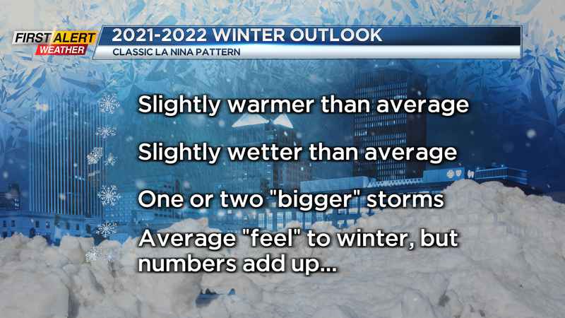
All this being said, with what we know now, here’s how winter 2021-2022 may break down:
- Typical La Niña, which means slightly above average precipitation, and slightly warmer than average temperatures.
- A few "bigger" synoptic (area-wide) snows, but maybe nothing to write home about.
- More "a little here, a little there" snows that may add up quickly in the end.
- A tolerable winter with a few blasts of cold, but again, nothing to write home about.
That brings us to the biggest wildcard for snow: Lake effect. If we get a few good blasts of cold, the lake effect could be a big factor. Lakes Erie and Ontario are running warm, and Lake Ontario doesn’t completely freeze over, so it can help to contribute lake effect snow into late winter.
Overall snow predictions: we may be looking at an above-average snowfall season, with 105-115" of snow. The new 30-year normal has us up to 100". Here’s how the First Alert Weather Team breaks down their snowfall predictions:
- Rich Caniglia: 119 3/4" (calling all Harry Potter fans!)
- Stacey Pensgen: 112"
- Glenn Johnson: 99"
- Alex Bielfeld: 110"
It’s been a slow start to the snow season so far. So, if our higher projections are going to verify, Mother Nature had better get to it!