First Alert Weather: It will turn ‘slushy’ this evening
[News10NBC]
ROCHESTER, N.Y. (WHEC) — Whether you are a winter enthusiast or a lover of mild weather, there is no arguing about the lack of snowfall this season.
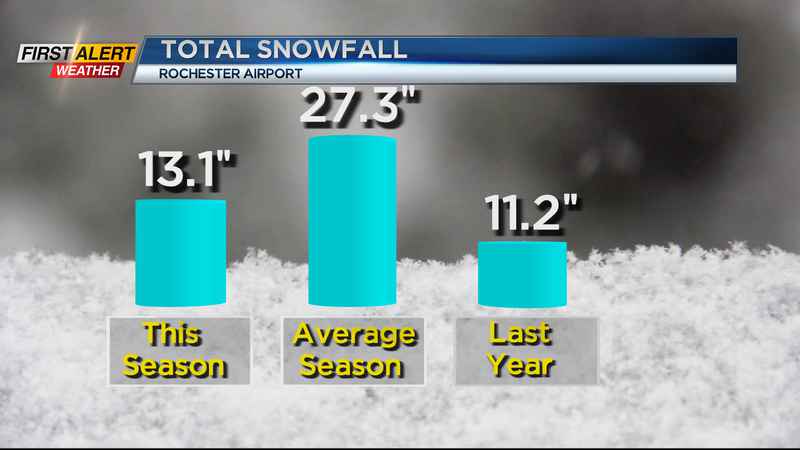
Our winter continues to sputter across Western New York as the temperature has been running above normal and snow measurements have been well below normal. The official seasonal snowfall at the Rochester Airport this morning is just 13.1 inches. That is more than 14 inches below normal for this date in the season.
It may not be much of a consolation, but there is some snow in the forecast for this evening. Look for an area-wide wet snowfall with an accumulation between one to two inches before tapering off around midnight. The snow may end as a little rain south of Rochester. The temperature will fall into the lower 30s.
The News10NBC First Alert meteorologists expect much of this accumulated snow will melt quickly tomorrow. Wednesday will be mainly dry with mostly cloudy skies and the temperature rising into the low 40s. The mild weather will not end there! Thursday, Friday and Saturday are not expected to be very winter-like. Each day will bring a temperature well into the 40s.
New Year’s Eve will bring mainly dry weather and as you ring in the new year look for mostly cloudy with a temperature in the mid-30s. New Year’s Day will feature a passing rain shower with the mercury rising into the mid to upper 40s. However, by Sunday the cold weather and an overall return to winter conditions is expected. Look for occasional snow with the temperature falling through the 30s into the 20s. It will be windy with lake effect snow for Monday and Tuesday. Both days the temperature will remain in the 20s.
For a complete rundown of the weather and Rochester’s only 10-day forecast, please join News10NBC.
————————————
For the latest weather update join us on News10NBC and download the WHEC First Alert Weather app.
Watch the latest full forecast at whec.com/weather.