Monroe County urges people to avoid unnecessary travel when winds pick up Tuesday afternoon
ROCHESTER, N.Y. — Monroe County is urging people to avoid unnecessary travel Tuesday afternoon and evening, when winds will pick up to potentially damaging speeds.
County Executive Adam Bello activated the Emergency Operations Center on Tuesday to coordinate a community-wide response to the wind storm. Here is a statement from the county executive:
“Expected wind gusts in excess of 60 mph could potentially blow down trees and power lines. The National Weather Service warns there may be widespread power outages. Residents should check local television and radio stations for the most up-to-the-minute updates on conditions. The county’s Office of Emergency Management is monitoring this developing situation and is working in cooperation with state, town and village officials and emergency responders. I ask residents to avoid unnecessary travel throughout the afternoon and evening, as conditions may be challenging with downed trees and power lines. In the event of power outages, please treat all traffic lights that may not be working as a 4-way stop.”
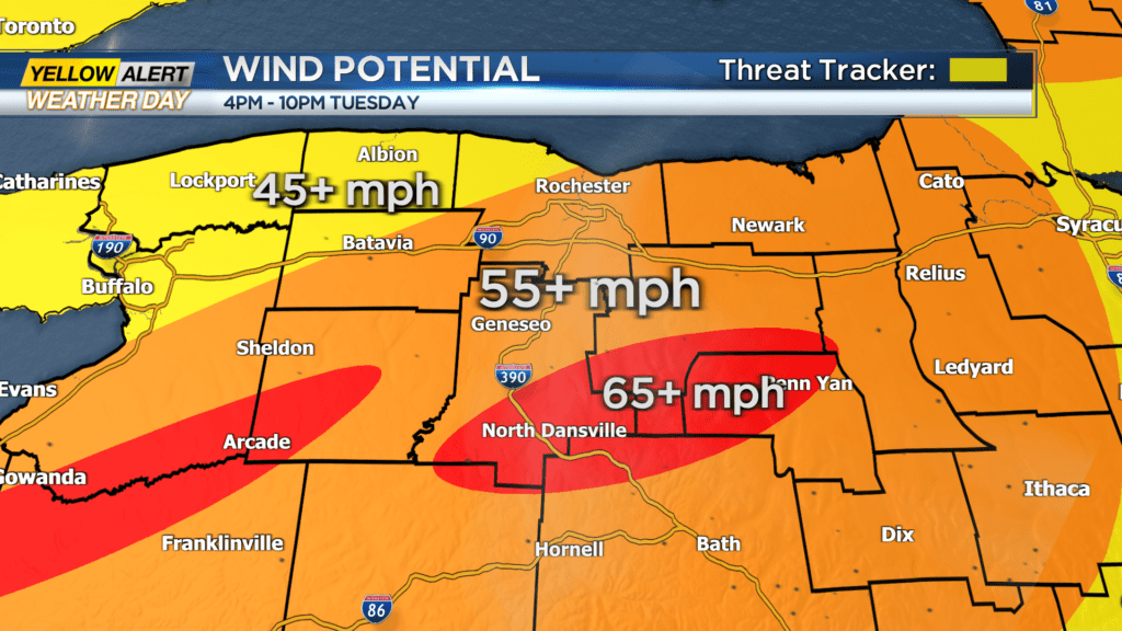
Tuesday’s storm will bring rain and winds that could exceed 65 miles per hour in areas southeast of Rochester like Penn Yan and North Dansville. In the Rochester metro area, wind speeds could exceed 55 miles per hour. You can see the latest forecast here.

How is the Rochester area preparing for the storm? According to RG&E, they’re pre-staged about 1,300 line workers and 200 tree crews across its service areas to assist with any potential outages.
Gov. Kathy Hochul also says state agencies are ready to clear brush and debris and get power restored if it goes out. The state has more than 8,000 utility workers and 75 generators are pre-positioned ahead of the storm.
“The vast majority of deaths during extreme flooding events come from individuals stuck in their cars,” Hochul said. “Six inches of swiftly moving water can make you lose control of the steering wheel or even knock you off your feet and two feet of water could literally sweep your car away. Remember we’re expecting up to four inches of rain tomorrow. So combining that with the multiple inches of melted snow, we’re talking about a very dangerous combination.”
You can see the latest on local power outages through the RG&E outage map and the National Grid outage map.